 Embark on construction confidence with SOUTHERN INSPECTION & TESTING's cutting-edge testing and inspection services, ensuring flawless concrete applications on large-scale projects. Dive into the precision core with our state-of-the-art concrete coring services, utilizing the latest drilling equipment for organized and accurate testing without disruption.
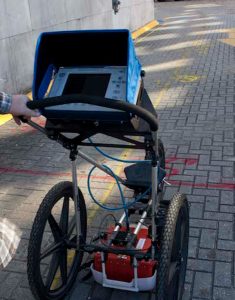
As pioneers in the field, we prioritize ground-penetrating radar in Harvey, LA, offering a comprehensive view of subsurface structures. Through radar pulses, our technicians detect reflected signals, isolating objects, material changes, voids, and cracks, ensuring the integrity of your concrete.
Trust SOUTHERN INSPECTION & TESTING to rectify concrete structures with cable dysfunction for post-tension cable repair. Safeguard your projects from potential failures that could damage structures and adjacent properties and pose physical harm.
Our commitment extends to initial visual materials inspection, both onsite and in the field, aligning with construction standards. Should complex issues arise, our knowledgeable staff ensures immediate reporting, assuring transparency throughout the process.
No inspection site is too challenging for Southern Inspection. Wherever your construction journey takes you, trust us to deliver unparalleled construction testing company, securing the strength and reliability of your concrete applications.
Geological Surveys
Delve into the depths of construction confidence with SOUTHERN INSPECTION & TESTING's advanced geological survey services. Powered by ground-penetrating radar, our cutting-edge methods reveal the complete subsurface and offer utility location services. We unveil a comprehensive picture through precise radar imaging, identifying objects, material changes, voids, cracks, and existing utility infrastructure.
Contact us today to uncover the full spectrum of our geological survey capabilities and enhance the precision of your construction endeavors.
Concrete Scanning
Concrete Imaging & Mapping
Radar Concrete Scanning is sometimes confused with Concrete X-Ray to locate post-tension cables and other objects in concrete construction prior to cutting or coring. We use Ground Penetrating Radar (GPR) equipment which uses radio waves that are safe and not gamma rays used in concrete x-ray equipment. The radiation from concrete x-ray equipment can be harmful to humans and therefore requires evacuation. GPR technology can also reduce the time and cost required for a concrete inspection because the results are available onsite in real time. Drilling or cutting through concrete floors, walls or ceilings can be dangerous and very costly if you don't know what is under the surface. Our GPR technicians can accurately & quickly locate rebar, find conduits and identify post-tension cables before it's too late. We can also measure concrete thickness and locate voids in concrete and sinkholes below the ground surface. For more information see our GPR vs Concrete X-Ray Comparison.
Our GPR Data Collection Process
Too often we hear from new clients, that even with a GPR concrete survey, they have hit conduits when coring or cutting an area they were told was clear of anomalies. Usually this is the result of inexperienced GPR technician or an incorrect scan process. In order to save time some GPR operators will simply do line scans (every 4"-6") and try to connect the dots instead of taking the time necessary to create a high resolution 3D grid. The simple line scan process may work some of the time to locate rebar. However, conduits and post tension cables can easily be missed. Although it takes a little longer to collect the data, using a 3D grid process (every 2"), this can save the costs of damaging conduits & post-tension cables and even possibly physical harm to the person doing the coring or cutting. Our highly trained GPR Technicians will not take that risk. Because of our staff's training and experience we can still "get-r-done" quickly and efficiently with quality results.
"Our primary goal as a GPR service company is to ensure the most accurate results for our clients. The following example is a testament of our commitment to using the correct GPR data collection process every time... On a large concrete imaging project of over 20,000 (2' x 2') scans by our GPR Technician the client did not have a single hit in the areas that were cleared. We believe it's always best to do it right the first time!"
Detailed Mapped Reports 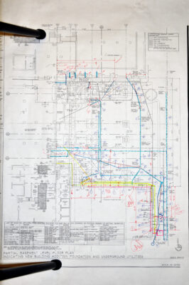
In addition to scanning and marking the site for objects located in a concrete inspection we can also provide detailed mapped reports. These reports include diagrams of the scanned areas with locations and depths of located anomalies plotted to scale. This can be used for pre-engineering or just save you money down the road if you need to do further work in that area.
Core Drilling
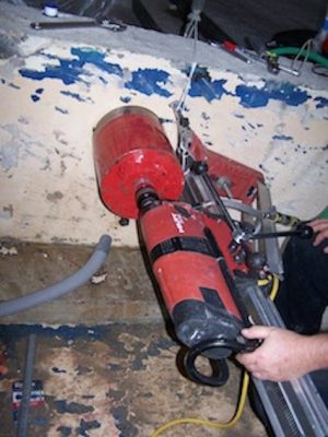
Southern Inspection & Testing can accommodate all of your coring needs. Whether you simply need a core sample for testing or holes cored in a concrete structure. We use carbide and diamond-tipped bits to drill holes into concrete walls and flooring.
Some of the most common needs for core drilling include:
- Creating a hole for:
- Electrical lines
- Internet cables
- Fiber optic lines
- Plumbing systems
- Sewer and floor drains
- HVAC openings
- Exhaust areas
- Core samples to test the integrity of a structure
No matter what size hole you need cored, Southern Inspection & Testing have the right tools and personnel to get it done right.